Project Description
To help identify and reduce the risks from impacts of post-wildfire flooding and debris-flows in Yavapai County, JE Fuller, alongside the Arizona Geological Survey (AZGS), conducted a multi-phase study to identify potential post-wildfire flooding and debris-flow hazard areas. The purpose of the project was to help the County and municipalities understand which areas are potentially at risk from the impacts of postfire flood and debris-flows and provide data for identifying and planning long-term flood control measures and mitigation needs, forest health initiatives, emergency management planning, and community planning efforts.
The tasks of this overall study include:
1. Conduct a county wide reconnaissance-level assessment to identify vulnerable areas at greater risks of impacts from post-wildfire flooding and debris-flows;
2. Quantify those risks in two smaller study areas; and
3. Identify targeted pre-disaster mitigation opportunities and strategies to reduce risks from post-fire floods and debris-flows.
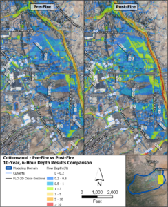
Flood hazards were evaluated by modeling the 10- and 100-year design storms using FLO-2D under current conditions and then under burned conditions using the simulated soil burn severity data. Results show that the post-fire discharges are estimated to be approximately 2 to 4 times larger than the pre-fire discharges. Post-fire debris-flow likelihood and volumes were also estimated using the simulated soil burn severity data for the 1-, 2-, and 5-year design storms. Modeled debris-flow volumes were then used to estimate probabilities of debris-flow inundation for peak-flow depths (maximum thickness of flow) of 10 cm and 50 cm for the 2- and 5-year design storms. Results from the debris-flow routing and inundation modeling indicate that the 10 cm and 50 cm peak-flow depths are likely limited in extent, but still indicate where flows may travel, which can help to identify and prioritize areas for mitigation efforts.
Location
Prescott, AZ
Client
Yavapai County Flood Control District
