Project Description
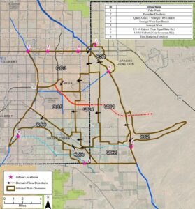
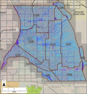
JE Fuller was selected by the Flood Control District of Maricopa County to update area master drainage studies and plans for a 110-square-mile region encompassing parts of southeast Mesa, eastern Gilbert, and the Town of Queen Creek. The study area, located in southeastern Maricopa County and extending into northcentral Pinal County, includes the City of Mesa, Town of Gilbert, Town of Apache Junction, and Town of Queen Creek. Bounded by US60 to the north, the East Maricopa Floodway to the west, Queen Creek to the south, and the Central Arizona Project canal to the east, the watershed is experiencing rapid development across residential, industrial, commercial, recreational, agricultural, and technological manufacturing sectors. Key transportation infrastructures within the watershed include the Phoenix-Mesa Gateway Airport, portions of the Loop 202 freeway, State Route 24, and US60. Prominent regional drainage features are the Powerline Floodway Channel, Ellsworth Channel, and Queen Creek, all draining into the East Maricopa Floodway. The Central Arizona Project Canal directs upstream runoff to several cross-drainage structures, channeling flows into the study area at specific points. Regional flood control structures impacting the area include the Powerline, Vineyard, and Rittenhouse Flood Retarding Structures, as well as the Sonoqui Dike. Land use within the watershed is diverse, comprising active and fallow agricultural lands, residential areas of varying densities, industrial and commercial zones, parks, and natural open desert. Many locations are undergoing rapid transformation, with developments in various stages from planning to construction. In Work Assignment No. 1, tasks encompassed comprehensive data collection, including interviews with project stakeholders and other relevant agencies. An initial informational newsletter was prepared for the project webpage hosted by the Flood Control District. Significant effort was dedicated to developing preliminary baseline FLO-2D models for the study area, covering nine domains with a total of 14.7 million 15-foot grids. These baseline models will be refined in future assignments by incorporating elements such as culverts, storm drains, levees, and channels.
Services Provided:
- Regional Drainage Study & Planning
- Watershed Characterization
- Stakeholder & Agency Coordination
- Data Collection & Baseline Model Development
- Future Planning & Model Refinement
Location
Mesa/Gilbert/Queen Creek, AZ
Client
Flood Control District of Maricopa County

