Project Description
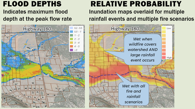
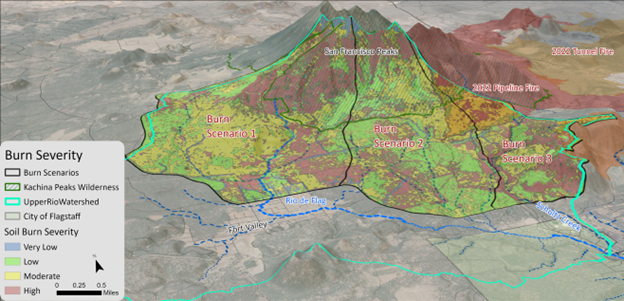
To better understand the potential post-fire flood risks to the Rio de Flag floodplain and its tributaries that originate from the San Francisco Peaks, JE Fuller performed a pre-wildfire assessment of post-fire flood risk using different fire burn scenarios that affect the watershed. JE Fuller utilized FlamMap Version 6.0 (2022), a fire behavior model, to determine potential wildfire scenarios and the associated SBS maps. The hypothetical fire scenarios were then modeled in FLO-2D modeling software for various design storm events to determine potential post-fire flood risk. Results from this study identified areas that have the highest risk for post-fire flooding in Coconino County and the City of Flagstaff. Results from the study were used by the Northern Arizona University Economic Policy Institute who noted that post-fire flooding impacts could cause economic impacts over $2 Billion to the City and surrounding area. JE Fuller also prioritized forest treatment in the watershed and assisted the Flood Control District in determining where funding should be allocated based on potential hydrologic impacts. Forest treatment is currently being completed by the USFS in partnership with Coconino County based on the results of the study. Finally, JE Fuller is currently preparing a prefire emergency mitigation plan to determine emergency access routes, barrier and sandbag needs, staging areas, and installation logistics, before a fire occurs.
Location
Flagstaff, AZ
Client
Coconino County Flood Control District